本科毕业设计(论文)
外文翻译
基于多尺度面向对象分类和概率霍夫变换的高分辨率图像建筑物提取
摘要:本文提出了一种基于多尺度面向对象分类和概率霍夫变换的高分辨率遥感影像建筑物提取系统。这可以分为两个不同的阶段:建筑屋顶提取和形状重构。第一阶段,首先将多光谱和全色高分辨率卫星图像进行融合,提高空间分辨率,增强颜色信息。将多分辨率图像分割应用于融合后的图像,在不同的空间尺度上形成不同层次的多边形原语,提供了不同分辨率下的场景视图。除了光谱信息外,色调、纹理、形状和上下文信息也以面向对象的方式进行评估。该分类基于模糊规则决策树分类器。通过对屋顶形状、纹理、背景和光谱信息的模糊评价,从屋顶多边形原语的适当空间尺度上进行重构和分类,提取建筑屋顶。在形状重构阶段,我们采用概率霍夫变换来划分屋顶主控线,该主控线显示了特定建筑屋顶的主要方向。根据主控线,提出了一种基于建筑物边界直线拟合的建筑物平方算法。实验表明,该方法能够正确地检测、提取和重构大部分矩形屋顶,具有一定的应用前景。
关键词:构建提取;面向对象分类;霍夫变换
ⅠINTRODUCTIONII.引言
Recent advancement of satellite remote sensing technology, eg the successful launch of Ikonos, QuickBird, provides global, accurate, very high resolution multispectral imagery (around 1 meter or better after fusion of the panchromatic with multispectral bands) to individuals, commercial organizations and governments for urban development applications.卫星遥感技术的最新进展(例如成功发射Ikonos,QuickBird)为个人、商业组织和政府提供全球范围内准确的高空间分辨率的多光谱图像(全色与多光谱波段融合后约1米或更高精度)。 Particularly, the extraction of building information from high resolution imagery has been one of the most interesting topics for remote sensing and computer vision scientists.特别是从高分辨率图像中提取建筑物信息一直是遥感和计算机视觉科学家最感兴趣的主题之一。
In general, current building extraction methods could be classified as two categories: The first kind of methodology is investigated most一般而言,目前的建筑物提取方法可分为两类:第一类方法使用最多,其extensively and deeply, which extracts buildings by using image information combined with altitude information, either derived from stereo images or from other sources.广泛而深入地通过使用与高度信息相结合的图像信息(来自立体图像或来自其他来源)来提取建筑物。 For example, Fraser et al.例如,Fraser等人(2002) present results on building extraction from Ikonos stereo images.(2002)从Ikonos立体图像中提取建筑物信息。一些操作方法Some operational methods have also been established, eg CSG method, and have been implemented on some commercial software systems.已经建立起来,例如CSG方法,并已在一些商业软件系统上实现。 The other kind ofmethod relies only on satellite remote sensing imagery.另一种方法仅基于卫星遥感图像,其It combines new image processing algorithm with new methods from pattern recognition, machine vision and artificial intelligence fields, to extract the roof of building semi-automatically or automatically.结合了新的图像处理算法和模式识别、机器视觉和人工智能领域的新方法,半自动或自动提取建筑物屋顶。 The method doesnt need height information and other prior knowledge.该方法不需要高度信息和其他先验知识。Compared with the first method, it has a more extensive application area but currently there are still some technical difficulties which should be overcome.与第一种方法相比,它具有更广泛的应用领域,但目前仍存在一些应克服的技术难题。
Zheltov (2001) adopts the linear extraction method proposed by Burns et al.Zheltov(2001)采用Burns等人(1986)提出的线性提取方法,(1986) and combines with the rectangular building model to extract building information from aerial images.并与矩形建筑模型相结合,从航空图像中提取建筑信息。Sohn and Dowman (2001) extract the polygon of building based on Fourier Transform and Binary Space Partitioning tree and combined with Building Unit Shape knowledge.Sohn和Dowman(2001)基于傅立叶变换和二元空间划分树提取建筑物的多边形,并结合建筑单元形状知识。Stassopoulou (2000) combines multi-scale region segmentation based on canny operator with edge segmentation to extract regional features (geometry shape, radiation characteristic, context information), and extracts building features by Bayesian network.Stassopoulou(2000)基于canny算子的多尺度区域分割与边缘分割相结合,提取区域特征(几何形状、辐射特征和背景信息),并通过贝叶斯网络提取建筑特征。Lin and Nevatia (1998) derives the analytic geometric relationship between building margin line and building shadows according to general illumination model to analyze the relationship of different ground features.Lin和Nevatia(1998)根据一般照明模型推导出建筑边缘线与建筑物阴影之间的解析几何关系,以分析不同地面特征的关系。
以上These methods normally combine specific edge detection, edge linking algorithm with semantic analysis of the relationship among detected lines, surfaces and their contexts.这些方法通常将特定边缘检测、边缘链接算法与检测到的线、表面及其背景之间的关系的语义分析相结合。They have shown relatively good result on airborne photograph because of its high signal noise ratio (SNR).由于其高信噪比(SNR),它们在航空影像上表现出相对较好的效果。 However on high resolution satellite imagery, the low spatial resolution and low SNR substantially increases the difficulties to locate and identify the exact building roof edges.然而在高分辨率卫星图像上,低空间分辨率和低SNR大大增加了定位和识别精确建筑物屋顶边缘的困难。
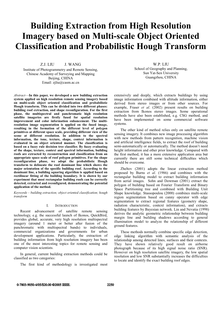
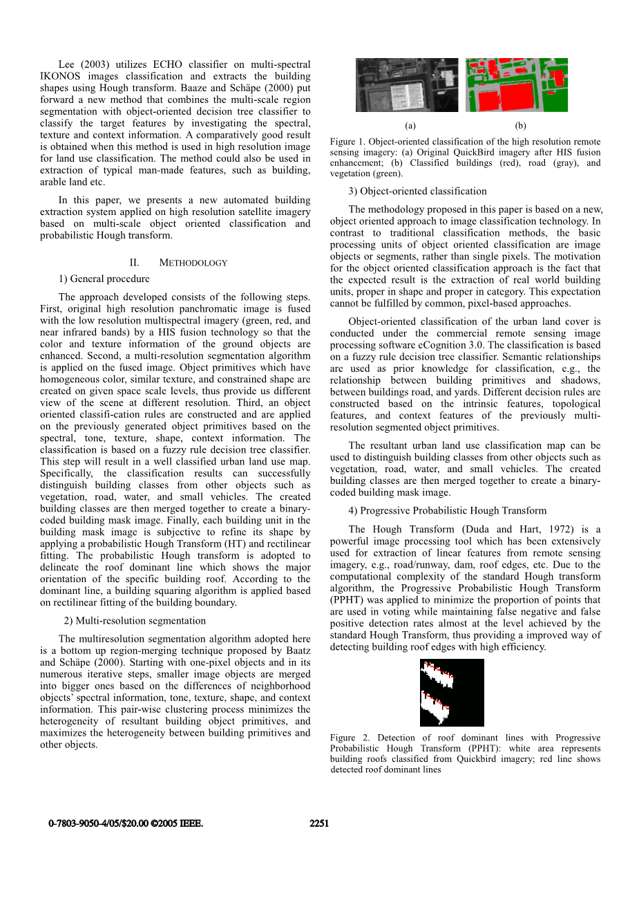
Lee (2003) utilizes ECHO classifier on multi-spectral IKONOS images classification and extracts the building shapes using Hough transform.Lee(2003)利用ECHO分类器对多光谱IKONOS图像进行分类,并使用霍夫变换提取建筑物形状。Baaze and Schauml;pe (2000) put forward a new method that combines themulti-scale region segmentation with object-oriented decision tree classifier to classify the target features by investigating the spectral, texture and context information.Baaze和Schauml;pe(2000)利用一种新方法即将多尺度区域分割与面向对象决策树分类器相结合,通过研究光谱、纹理和背景信息对目标特征进行分类。A comparatively good result is obtained when this method is used in high resolution image for land use classification.此方法用于高分辨率图像的土地利用分类时,获得了相对好的结果。 The method could also be used in extraction of typical man-made features, such as building, arable land etc. In this paper, we presents a new automated building extraction system applied on high resolution satellite imagery based on multi-scale object oriented classification and probabilistic Hough transform.该方法还可用于提取典型的人造特征,如建筑物、耕地等。
在本研究中,我们提出了一种基于多尺度面向对象分类的高分辨率卫星影像自动建筑物提取和概率霍夫变换。
II.II METHODOLOGY方法
1)1)General procedure一般程序
The approach developed consists of the following steps.该方法包括以下步骤:First, original high resolution panchromatic image is fused with the low resolution multispectral imagery (green, red, and near infrared bands) by a HIS fusion technology so that the color and texture information of the ground obj
剩余内容已隐藏,支付完成后下载完整资料


英语原文共 4 页,剩余内容已隐藏,支付完成后下载完整资料
资料编号:[276724],资料为PDF文档或Word文档,PDF文档可免费转换为Word
以上是毕业论文外文翻译,课题毕业论文、任务书、文献综述、开题报告、程序设计、图纸设计等资料可联系客服协助查找。
您可能感兴趣的文章
- GIS矢量地图的鲁棒水印方案外文翻译资料
- 中国相似地理位置发达地区房价影响因素的差异——以西安高新区和沣渭新区为例外文翻译资料
- 集成数据在城市土地利用变化时空动态监测的应用——以印度金奈都市为例外文翻译资料
- 全球地表水及其长期变化的高分辨率制图外文翻译资料
- 造成沿海大型城市内涝灾害的主要因素识别——以中国广州为例外文翻译资料
- 基于SFPHD框架的中国快速城市化地区城市生态系统健康综合评价方法外文翻译资料
- 基于绿地演变的未来城市地表热岛强度的多情景模拟预测外文翻译资料
- 中国大陆272个城市地面和冠层城市热岛强度的长期趋势外文翻译资料
- 与孟加拉湾热带气旋有关的中国低纬度高原远距离降雨事件外文翻译资料
- 新丰江水库流域GPM IMERG降水产品评价及水文效用研究外文翻译资料


